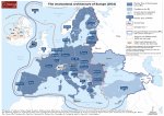
Map. The Institutional Architecture of Europe (2024)
Par , , , le 23 avril 2024.
On an idea from Maxime Lefebvre who speaks here in a personal capacity. Production : Maxime Lefebvre, Former ambassador, professor of international relations at ESCP, scientific director of the “International Business & Diplomacy” master’s degree, author of "Jeu du droit et de la puissance. Précis de relations internationales", PUF Major. Pierre Verluise, Doctor in Geopolitics, founder of Diploweb.com.
Creation of the map : AB Pictoris is a young French company founded by Blanche Lambert, independent cartographer. Passionate about cartography and geopolitics, she obtained a Master’s degree in Geopolitics (cyber course, IFG, Paris VIII) and in Geostrategy (Sciences Po Aix) after a degree in Geography and Regional Planning (Paris I).
This map shows the overlapping between the EU, NATO, and the European Political Community launched in 2022 in a format close to the Council of Europe. A few countries have specific statutes (UK and Norway NATO and non EU members, neutral EU countries not members of NATO, Kosovo non legally recognized by all States, Switzerland). The Schengen area for the free movement of persons is a bit more limited and the map also displays the Union for the Mediterranean which gathers EU members and mediterranean partners.
The year 2024 will be a significant one for the European Union, marked by the election of representatives to the European Parliament in June. European citizens and candidates in the elections will find here material that will help deepen their thinking and feed their debates.

Numerous institutions operate in cooperation and competition across geographical Europe. It is challenging to navigate this landscape, especially since these institutions’ schedules are not aligned. Without claiming that this map is exhaustive - which would make it unreadable - it provides a snapshot of the situation as of January 2024. For example, Denmark is shown as a member of a 31-member NATO, while Sweden is not listed in this way, because its membership is still in the process of being finalized (it will likely be finalized sometime in 2024).
This map shows the member countries of the European Union, the candidates for EU membership, the countries that have applied to the EU, the members of NATO, neutral countries, the Schengen Area, the European Political Community and the Council of Europe. The countries part of the Union for the Mediterranean and the ones participating in the 5+5 initiative are indicated on the inset map.
Thus, in about ten items, you have a clear cartographic view of the institutional architecture of Europe as of January 2024. Another map presents the Geopolitics of the European Union as of January 2024.
Bonus cartographique Diploweb
 |
Titre du document : Map. The Institutional Architecture of Europe ( January 2024) Click on the thumbnail to enlarge the map : The institutional architecture of Europe (2024). Production : M. Lefebvre, P. Verluise. Design made by AB Pictoris in January 2024 for Diploweb.com Document ajouté le 23 avril 2024 Document JPEG ; 889493 ko Taille : 1200 x 847 px Visualiser le document |
This map shows the overlapping between the EU, NATO, and the European Political Community launched in 2022 in a format close to the Council of Europe.
Pour ne rien rater de nos nouvelles publications, abonnez-vous à la Lettre du Diploweb !
Direction

Directeur, P. Verluise
Conseil scientifique
Mentoring et coaching géopolitique
Présenter le Diploweb.com
Charte du site
Auteurs
Proposer un article
Retrouvez la chaîne Diploweb sur :


