

Map. Geopolitics of the European Union (2024)
Par , , , le 13 février 2024.
On an idea from Maxime Lefebvre who speaks here in a personal capacity. Production : Maxime Lefebvre, Former ambassador, professor of international relations at ESCP, scientific director of the “International Business & Diplomacy” master’s degree, author of "Jeu du droit et de la puissance. Précis de relations internationales", PUF Major. Pierre Verluise, Doctor in Geopolitics, founder of Diploweb.com.
Creation of the map : AB Pictoris is a young French company founded by Blanche Lambert, independent cartographer. Passionate about cartography and geopolitics, she obtained a Master’s degree in Geopolitics (cyber course, IFG, Paris VIII) and in Geostrategy (Sciences Po Aix) after a degree in Geography and Regional Planning (Paris I).
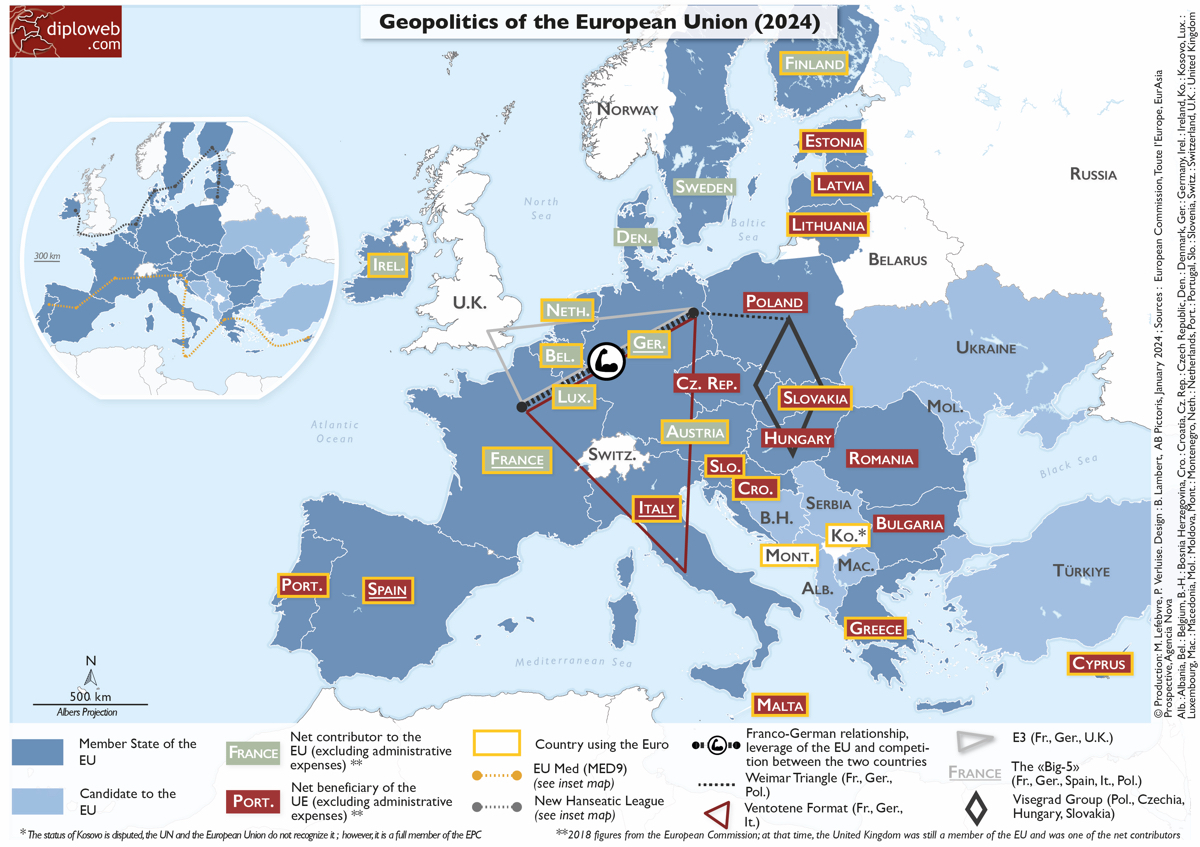
The year 2024 will be significant for the European Union, with the election of representatives to the European Parliament in June. As the French proverb goes, ’When it’s unclear, there’s something fishy’, and this is often the case with European matters. This map aims to clarify the fundamentals, as well as the convergences or divergences that need to be considered to gain a deeper understanding of the geopolitics of the European Union.
This map displays the importance of big countries in the EU (the Franco-German partnership, but also the triangles it makes with Italy or the UK or Poland), and the opposition between Northern Europe, rich and net contributor to the EU budget (the New Hanseatic League, that Germany refused to join), and Southern Europe, less developed and more supportive of solidarity (MED9 format including France).
So, with about a dozen items, you have a clear cartographic vision of the Geopolitics of the European Union (2024). You will find on Diploweb a map dedicated to ’The Institutional Architecture of Europe (2024).’ These two maps have been designed as a system. »
Bonus cartographique Diploweb
|
Titre du document : Map. Geopolitics of the European Union (2024) Click on the thumbnail to enlarge the map : Geopolitics of the European Union (2024). Production : M. Lefebvre, P. Verluise. Design made by AB Pictoris in January 2024 for Diploweb.com Document ajouté le 13 février 2024 Document JPEG ; 816449 ko Taille : 1200 x 847 px Visualiser le document |
This map displays the importance of big countries in the EU (the Franco-German partnership, but also the triangles it makes with Italy or the UK or Poland), and the opposition between Northern Europe, rich and net contributor to the EU budget.
Pour ne rien rater de nos nouvelles publications, abonnez-vous à la Lettre du Diploweb !
Direction

Directeur, P. Verluise
Conseil scientifique
Mentoring et coaching géopolitique
Présenter le Diploweb.com
Charte du site
Auteurs
Proposer un article
Retrouvez la chaîne Diploweb sur :