

Mer de Chine du Sud. Code de conduite : la grande chimère
Par , le 30 janvier 2016 


Général (2s). Membre du groupe de réflexion Asie 21 (asie21.com)
Illustré de 7 cartes. Une version en français, puis une version en anglais. Espérant desserrer l’étreinte de la Chine en mer de Chine méridionale, les pays d’Asie du Sud-est ont fini par obtenir de Pékin qu’il accepte de négocier un code de conduite des parties en mer de Chine du Sud pour remplacer l’inefficace Déclaration de conduite qui avait été adoptée le 4 novembre 2002. L’ambition d’un tel code est qu’il soit contraignant. Mais aujourd’hui, tant que la Cour permanente d’arbitrage n’a pas encore rendu son verdict dans l’affaire Philippines contre Chine, et que se profile la date fatidique du 9 mai 2016 pour les élections générales aux Philippines, car tout est lié, la question qui se pose est de savoir, si un jour les négociations aboutissent finalement à un COC, le résultat ne risque pas de finalement se retourner contre les riverains sud-est asiatiques.
INTRODUCTION
APRES BIEN DES ANNEES de sollicitations de la part de l’Association des nations d’Asie du Sud-Est (ASEAN) auprès de la Chine dans le but d’établir un code de conduite des parties en mer de Chine du Sud, Pékin a enfin donné, depuis mars 2014, l’impression de bien vouloir répondre aux sollicitations de l’ASEAN et de s’engager dans les négociations afférentes. Pourquoi un Code de conduite alors qu’il existe déjà une Déclaration de conduite des parties en mer de Chine du Sud, texte sensé être entré en vigueur dès sa signature le 4 novembre 2002 ? Pourquoi la Chine, après tant d’années, s’est-elle résolue à ne plus camper sur ses positions de refus ? A quoi faut-il s’attendre le jour où ce code sera adopté, s’il le devient ?
I . L’ARBITRAIRE TRACE CHINOIS EN NEUF / DIX TRAITS
Pour comprendre il est nécessaire de revenir à l’élément essentiel qui s’est construit autour des contentieux territoriaux insulaires en mer de Chine du Sud, entre la Chine et le Vietnam d’abord, les Philippines ensuite, la Malaisie et Brunei plus tard encore [1].
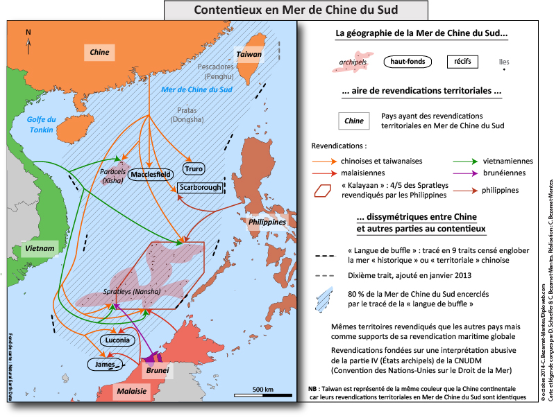
Relevons au passage que la contestation de Taiwan ne se fait pas contre celle de la Chine continentale mais de concert avec elle contre les quatre pays précités. Et cela au nom des mêmes intérêts communs qui sont ceux de la grande Chine. Pour preuve : si la Chine est en contentieux avec les quatre nations concernées d’Asie du Sud-est, elle n’a jamais, sauf méconnaissance de l’auteur, contesté la présence de la Chine nationaliste sur Itu-Aba, aussi dénommée Taiping, île principale de l’archipel des Spratleys. L’occupation de ce lieu par la Chine nationaliste date de 1947, à l’époque où le Kuomintang était encore au pouvoir bien qu’il commençât à être sérieusement étrillé par les forces communistes de Mao Zedong sur le continent. Mais 1947 est aussi la date à laquelle les géographes nationalistes dessinent sur la carte de la mer un tracé sensé circonscrire l’espace à l’intérieur duquel existent des différends territoriaux entre la Chine et ses voisins maritimes. Et ce tracé est bien l’élément essentiel que les disputes territoriales ont généré et continuent à générer.
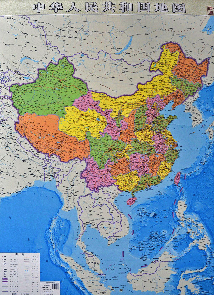
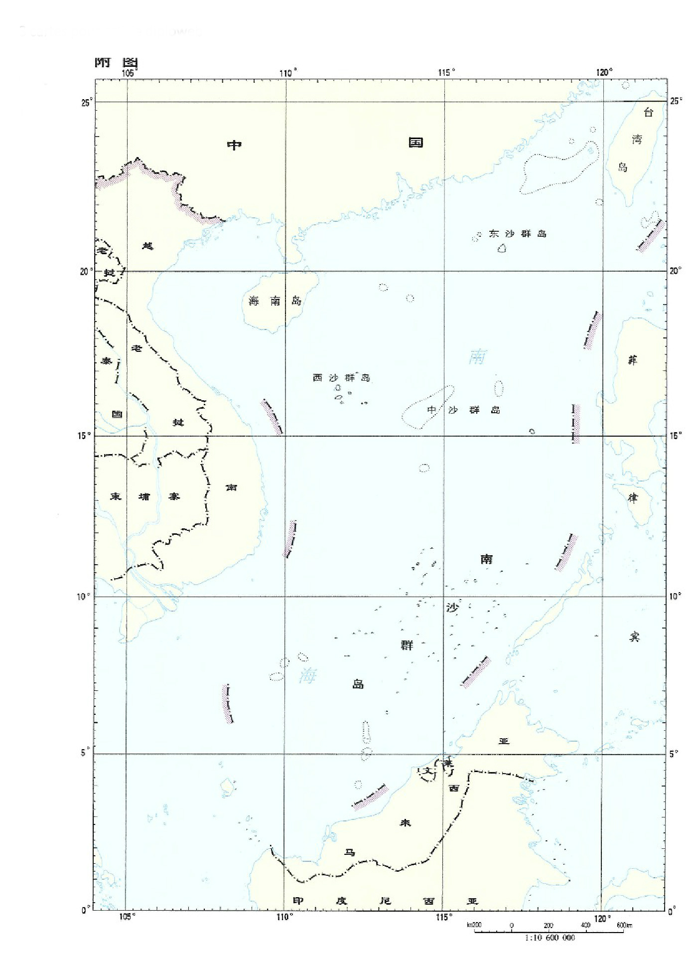
Depuis 1947, il a connu diverses représentations. Il n’est pas nécessaire de revenir sur toutes. Celle qui est retenue depuis longtemps est celle en neuf traits et, depuis le 11 janvier 2013, en dix [2].
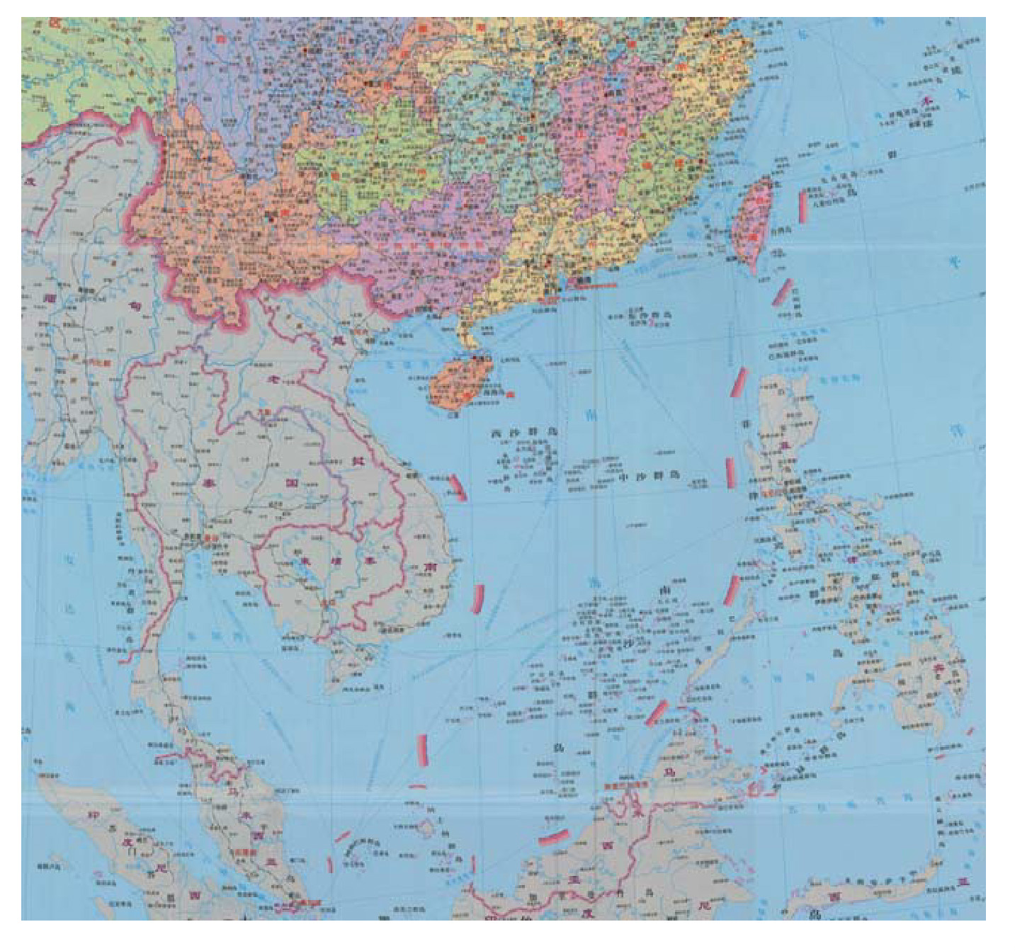
Un tel tracé ne modifie en rien l’aspect du dessin original en neuf marques. Il ne fait que rajouter à la figuration existante un dixième coup de crayon. Celui-ci est inscrit à l’est de Taiwan, pour bien signifier que Formose fait partie du territoire national chinois. A la suite de la publication de janvier 2013 les Chinois éditent une nouvelle carte, le 26 juin 2014, cette fois-ci intégrale, intitulée « carte de la République populaire de Chine » (Zhong hua renmin gonghe guo di tu). Sur cette planche le graphisme utilisé pour représenter les frontières nationales, épaisseur et couleur des traits, est exactement le même pour illustrer frontières terrestres et frontières maritimes. Seule différence : la frontière maritime reste en représentation discontinue [3].
Depuis la Chine fait silence sur ce tracé en dix traits. Tant et si bien que la presse internationale, erreur fondamentale, continue à prendre le dessin en neuf comme référence. En revanche les états-majors chinois quant à eux, essentiellement ceux des services de police maritime, raisonnent désormais bel et bien en fonction de la démarcation en dix traits.
II. LA « LANGUE DE BUFFLE » : UN ESPACE MARIN CONFISQUE PAR LA CHINE
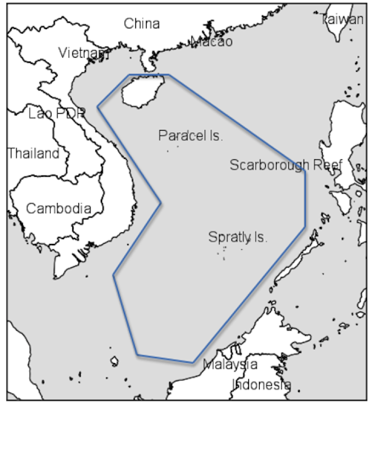
Depuis 1947 la forme générale du dessin n’a pas varié. Il enserre un immense espace de la mer, ce qui lui donne une forme de grande langue, la « langue de buffle » comme les pays d’Asie du Sud-Est la dénomment par dérision. Elle couvre, selon les estimations faites, au « doigt mouillé » il faut bien le reconnaître, entre 80 et 90% d’un espace général qui équivaut à celui de la Méditerranée.
Si en 1947 le dessin chinois a pour objet de déterminer vaguement une zone à l’intérieur de laquelle se confrontent les ambitions territoriales de la République de Chine à la présence de la puissance coloniale française en Indochine sur ces mêmes territoires marins, cet objet évolue par la suite, au fur et à mesure des années. Parce que le tracé en neuf / dix traits n’a jamais fait l’objet d’une description précise de la part des Chinois, notamment parce que ces derniers n’ont livré aucune coordonnée des segments qui le composent, chercheurs comme politiciens ou stratèges continuent en permanence à se poser la question de la signification dudit tracé. Mais il existe. Avec ou sans coordonnées pour le décrire plus précisément. Mais il est là. Et bien là. Or est-il vraiment nécessaire de disposer de coordonnées exactes pour constater sa réalité et les intentions réelles qu’il affiche ? Pékin s’en amuse qui, de son côté, continue à jouer sur le velours de cette perplexité étrangère qui hésite à prendre à bras le corps la réalité du problème.
Après que la Convention des Nations unies sur le droit de la mer (CNUDM) ou Convention de Montego bay eut été adoptée, en 1982, l’on a pensé que les Chinois considéraient la « langue de buffle » comme une zone économique exclusive (ZEE), ce qui modulait leur prétention selon laquelle l’espace couvert était une mer historique, deux conceptions qui, quelles qu’elles soient, n’ont aucune valeur en regard du droit de la mer. Ce ne peut en effet être une ZEE puisque son étirement à partir des côtes de la Chine continentale dépasse démesurément les 200 milles marins qu’autorise la CNUDM. Il pourrait cependant en être autrement si la souveraineté sur les archipels et autres reliefs marins revendiqués par Pékin lui était reconnue. Mais pour l’heure, malgré l’installation chinoise de force sur ces structures rocheuses, elle n’est acceptée de personne. Dans le second cas, la Chine ne peut pas revendiquer la « langue de buffle » comme mer historique pour plusieurs raisons liées aux dispositions fixées par la CNUDM. La première est que la Convention ne retient pas de caractère historique aux mers mais seulement à certaines baies, dans des conditions bien déterminées, ou à des espaces marins limités sous réserve que le prétendant puisse démontrer qu’il est détenteur du titre, au sens propriétaire du terme. Ce n’est pas le cas de Pékin sur la mer de Chine méridionale qui par ailleurs, une fois tracées les limites des ZEE des autres états côtiers, comporte en son centre des portions de haute mer. Or en vertu de l’article 89 de la Convention, illégitimité des revendications de souveraineté sur la haute mer, « Aucun Etat ne peut légitimement prétendre soumettre une partie quelconque de la haute mer à sa souveraineté ».
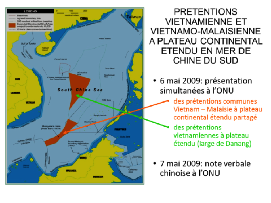
L’affirmation d’une souveraineté chinoise sur la « langue de buffle » apparaît déjà beaucoup plus clairement le 7 mai 2009 lorsque, par notes verbales numéros CML/17/2009 [4] et CML/18/2009 [5] adressées au Secrétaire général des Nations Unies, émises en vigoureuse réaction aux prétentions d’une part unilatérale vietnamienne et d’autre part commune vietnamo-malaisienne à plateaux continentaux étendus en deux zones distinctes de la mer de Chine méridionale [6], Pékin oppose ce qu’il estime être des droits fondés sur le tracé en neuf traits. Ces deux notes sont en effet accompagnées d’une annexe où figure la carte de l’espace marin sur lequel la Chine entend faire reconnaître sa pleine souveraineté, un espace méticuleusement délimité par le fameux tracé [7].
Et enfin, la carte du 26 juin 2014 [8] démontre clairement que la Chine entend faire de la mer de Chine du Sud une mer territoriale. Il est cependant à noter que si le message graphique est clair, Pékin n’a pas encore déclaré officiellement que l’espace enserré dans le tracé en neuf /dix traits constituait ses eaux territoriales. Pour cela il faudrait qu’il ait produit un document qui s’inscrive dans la même veine que les notes verbales du 7 mai 2009, ce qui officialiserait la revendication sur ces nouvelles bases.
III. LES ACTES CHINOIS D’APPROPRIATION DE LA MER DE CHINE DU SUD
Et comme la Chine se considère désormais souveraine sur tout cet espace, elle y agit arbitrairement, tant à l’intérieur que sur sa périphérie telle que déterminée par le tracé incriminé.
Elle s’y installe progressivement, de gré ou de force : en 1974 en parachevant la conquête des Paracels commencée en 1947 ; au mois de mars 1988 en s’emparant de vive force de huit îlots des Spratleys contre le Vietnam ; au début de 1995 en s’installant d’autorité sur Mischief reef, au nord est des Spratleys, contre les intérêts philippins autant que vietnamiens ; à partir d’avril 2012 en investissant Scarborough reef contre les Philippines ; et depuis la fin du mois de décembre 2013 en bouleversant intégralement, par des travaux titanesques, les huit reliefs marins conquis en 1988.
Sur le plan administratif, le 20 juin 2012, elle élève au rang de quasi-préfecture le district des Sansha, ou « trois bancs », plutôt que « trois sables » comme le voudrait une traduction littérale. Cette circonscription, qui est une subdivision de la province de Hainan, point fondamental, a pour mission d’administrer les trois bancs que sont les archipels des Paracels, (Xisha ou Banc de l’ouest) et des Spratleys (Nansha ou Banc du sud), et de Zhongsha qundao ou archipel du Banc du milieu. Ce dernier est un archipel complètement factice qui prétend agglomérer Scarborough reef et de multiples hauts-fonds, dont le plus important est le banc Macclesfield, en un tout qui se voudrait acceptable [9]. La responsabilité dont est investie la sous-préfecture des Sansha est l’un des témoignages patents de la volonté chinoise d’administrer l’espace couvert par la « langue de buffle » comme s’il s’agissait d’une mer territoriale. C’est ce que Pékin entend démontrer en y faisant patrouiller ses multiples agences para-navales : garde-côtes, surveillance maritime, sécurité maritime, douanes, surveillance des pêches.
Depuis le 1er janvier 2014 cette toute dernière force a vu son activité s’amplifier du fait de la décision chinoise de déterminer un espace de pêche dans lequel aucun étranger ne peut opérer sans l’autorisation préalable de Pékin. Or cet espace de forme polygonale coïncide grossièrement, sauf en son nord-est, avec la « langue de buffle » [10].
Une telle coïncidence n’est pas fortuite. Elle démontre bien que la Chine entend signifier qu’elle est maîtresse sur toute cette partie de mer. Parmi les étrangers sont évidemment comptés les autres états côtiers de la mer de Chine méridionale, états qui, de ce fait, ne peuvent plus opérer dans leurs ZEE respectives que dans la crainte de voir leurs pêcheurs appréhendés par les garde-pêches chinois.
Enfin, partout sur la périphérie la Chine conteste aux autres riverains le droit de procéder à des activités d’exploration-exploitation pétrolière au motif qu’ils exercent ces droits à l’intérieur du tracé en neuf / dix traits. C’est ce qui a amené la Chine, surtout entre 2006 et 2011, à exercer des pressions énormes non seulement sur les compagnies pétrolières sud-est asiatiques mais aussi sur les compagnies étrangères ayant passé contrat avec celles-ci. Au point que les Etats-Unis ont été contraints de menacer la Chine de représailles si elle continuait ainsi à harceler leurs sociétés.
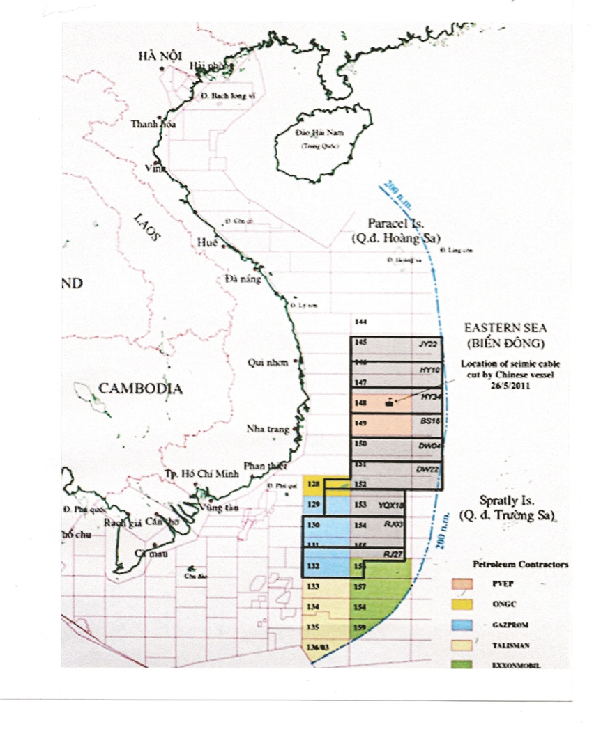
Dans cette stratégie de barrage aux activités pétrolières, la Chine instrumentalise sa compagnie nationale spécialisée dans l’exploration-exploitation en mer, la China national oil offshore company (CNOOC). C’est ainsi que le 23 juin 2012, CNOOC lance un appel à candidature internationale pour opérer sur neuf blocks au large des côtes vietnamiennes, neuf blocks qui mordent largement sur plusieurs de ceux du Vietnam, quant à eux bel et bien situés en ZEE vietnamienne et déjà ouverts en toute légalité à la coopération internationale [11].
Enfin des unités chinoises de police maritime, au moins par trois fois, les 26 mai [12] et 9 juin 2011 et le 30 novembre 2012, ont recours à des actions violentes contre des bâtiments vietnamiens de recherche sismique. A pleine vitesse, les navires des garde-côtes chinois se ruent sur les prétendus intrus pour venir sectionner avec leur proue les antennes acoustiques linéaires de détection – localisation tractées en poupe des bateaux de Petrovietnam. La Chine exerce des pressions identiques, bien que moins violemment, contre la Malaisie et les Philippines dans leurs ZEE respectives.
Si de tels graves événements se sont produits surtout depuis 2006, d’autres incidents importants, hormis ceux déjà cité liés aux opérations chinoises de conquête de vive force, avaient toutefois déjà eu lieu au cours des années précédentes contre les intérêts des riverains d’Asie du Sud-est. C’est ce qui avait amené ces états, espérant obtenir que les Chinois cessent leurs actes à connotation franchement hégémonique, à proposer à Pékin l’établissement d’un code de conduite. Mais à l’époque la perspective d’un code, qui serait contraignant quant au respect des engagements pris, ne convenait pas du tout à la capitale chinoise. C’est pourquoi les conversations d’alors n’ont abouti qu’à ce code en format réduit qu’est la Déclaration des parties en mer de Chine du Sud (Declaration of the parties in the South China Sea / DOC [13]). Cet ersatz d’accord, dont l’objet était et reste encore celui d’espérer ramener la sérénité dans les relations en mer entre la Chine et les pays de l’ASEAN, est un alignement de bonnes intentions qui, si chacun acceptait de les suivre en toute bonne foi, devraient avoir l’effet escompté.
Or il n’en est rien puisque dès le départ la Chine, considérant qu’en opérant à l’intérieur de la « langue de buffle » elle le faisait dans des eaux à minima sous sa souveraineté avant que plus tard elles ne deviennent affichées comme territoriales, a continué à se comporter en maîtresse arbitraire sur la totalité de l’espace. Tant est si bien que si l’un ou l’autre des états voisins, Vietnam, Philippines, Malaisie, Brunei, Indonésie, opérait et opère encore aujourd’hui chacun dans sa propre zone économique exclusive mais aussi dans l’espace qui, de cette ZEE, mord au-delà du tracé en neuf /dix traits, ce n’est pas, aux yeux de la Chine, elle qui est en tort et ne respecte pas la déclaration de conduite, mais bien ces-dits pays. C’est la raison pour laquelle l’application de la Déclaration de conduite est restée jusqu’à présent sans effet, d’autant que les onze négociateurs sont toujours en train de discuter de ses modalités d’application. C’est aussi la raison pour laquelle, à cause de cet échec et à cause de l’arbitraire chinois sur le bassin, les pays d’Asie du Sud-est sont revenus à la charge pour demander à Pékin d’accepter de négocier un code de conduite (Code of conduct of the parties in the South China Sea / COC) contraignant. Ainsi espèrent-ils obliger la Chine à respecter ses engagements et non plus les outrepasser comme elle le fait dans le cadre de la DOC.
IV. UN CODE DE CONDUITE DANS LA SITUATION ACTUELLE : UN DANGER POTENTIEL POUR LES PAYS D’ASIE DU SUD-EST
Ainsi la Chine a accepté, depuis mars 2014, d’entrer dans ce cycle des négociations, mais en temporisant puisqu’elle demande, avant de signer un COC, que la DOC trouve son plein effet. Ce comportement dilatoire a amené plusieurs auteurs à considérer qu’il était en réalité la manifestation du refus chinois d’aboutir à un COC. Or tout bien considéré il ne s’agit en réalité que d’une manœuvre de retardement destinée à donner à Pékin le temps de consolider pleinement sa présence en mer de Chine du Sud, au travers de la poursuite de la militarisation des îlots qu’il continue à bétonner, que ce soit dans les Paracels ou les Spratleys, et au travers de la dimension massive qu’il confère à rythme accéléré à ses moyens de police maritime.
Ce que ne voient pas venir les pays d’Asie du Sud-est derrière cette négociation dont ils espèrent qu’elle aboutira à un accord qui leur donnera plus de sécurité face à la Chine, c’est le contraire qui se prépare. Du moins tant que le tracé en neuf / dix traits existe. En négociant le futur COC, voulu contraignant, ils préparent les armes que la Chine pourra tourner contre eux demain. Puisque déjà aujourd’hui ces pays sont en tort, au regard de Pékin, lorsqu’ils osent exercer leurs activités dans la partie que la « langue de buffle » chevauche sur leurs propres ZEE. Par conséquent et à situation semblable à celle de maintenant, lorsque le COC sera adopté, le tort des riverains sud-est asiatiques restera demain le même qu’aujourd’hui. En raison de cet état de fait, par conséquent de sa possible extension dans l’avenir, et dès lors que l’application du COC sera contraignant, il confèrera tout pouvoir à la Chine pour intervenir par la force contre les contrevenants. A cause de l’engagement de ces pays dans le dit COC la Chine en appliquera finalement contre eux les dispositions dont ils auront espéré qu’elles les protègeraient. Si l’on veut bien regarder ce projet sous l’angle de la vision chinoise, les pays d’Asie du Sud-est fourbissent les armes qui se retourneront contre eux. C’est pourquoi, à ce stade, l’aboutissement envisageable à un COC n’est qu’une illusion quant aux effets d’apaisement à en attendre, tant en tout cas qu’existe le tracé en neuf / dix traits.
V. LE VERDICT ATTENDU PAR LEQUEL TOUT PEUT CHANGER OU TOUT PEUT S’AGGRAVER
En revanche ce COC pourrait prendre tout son sens si d’aventure la Cour permanente d’arbitrage (CPA), à La Haye, à la suite de la plainte déposée le 22 janvier 2013 par Manille contre Pékin pour empiètement de la « langue de buffle » sur la ZEE philippine, devait, en regard du droit de la mer, prononcer illégal le tracé en neuf / dix traits. Harassées de voir leurs activités contrecarrées dans leur propre ZEE par la Chine, lasses de ne pas voir aboutir ses pourparlers en bilatéral avec Pékin, Manille avait fini par se résoudre à intenter un recours contre l’administration nationale chinoise devant le tribunal international.
Dans le cas où, au bout du processus, la CPA énoncerait la conclusion favorable qu’espère Manille, la Chine serait juridiquement dépourvue de son pouvoir discrétionnaire en mer de Chine du Sud. Et cela même si ses instances gouvernementales, mais aussi académiques, eurent tôt fait de déclarer que leur pays ne s’alignerait pas sur la décision en perspective, au motif que le jugement aura été rendu hors d’une présence nationale chinoise. En effet Pékin contestant la démarche en cours ne s’est pas, depuis le début, présenté comme défendeur et persiste encore aujourd’hui dans cette position. En cela il est, en regard des dispositions juridiques existantes, pleinement dans son droit. Toutefois, malgré sa position de refus, la Chine s’est ménagé la possibilité de se faire entendre. Le 7 décembre 2014 en effet elle publie une déclaration (position paper) qui, en 93 points, constitue de fait un plaidoyer indirect pour sa défense [14]. La CPA, comme elle y est contrainte par les règles de procédure inhérentes pour juger en équité, a pris en considération la démarche. De même que, en vertu des mêmes dispositions en vigueur, le refus chinois ne peut empêcher la procédure de se poursuivre [15]. La Cour en tire donc toute sa légitimité pour statuer. C’est pourquoi, depuis la date à laquelle le gouvernement Aquino III a présenté son « mémoire en demande », l’examen de l’affaire se déroule en toute conformité et sans ambiguïté en regard du droit international.
Au bout du compte si le verdict prononcé par la Cour devait être celui attendu par la partie demanderesse, et à la suite par les autres états bordiers de la mer de Chine du Sud, cela renforcerait leur droit plein et entier à opérer dans leurs ZEE respectives. Dans ces conditions, et sous réserve que la Chine accepte de continuer à négocier en vue de signer son adhésion à un code de conduite des parties en mer de Chine du sud, un tel instrument prendrait tout son sens. Il n’éviterait sans doute pas de nouveaux incidents dans les secteurs litigieux résiduels autour des archipels. Mais dans ces conditions en enlevant, au moins sur le plan juridique, sa suprématie à la Chine, toutes les parties seraient mises à égalité dans une appréciation des torts commis. De plus un tel verdict consacrerait définitivement le droit sacré de la libre navigation internationale sur et au-dessus d’un espace authentiquement international, et non pas confisqué par un état chinois au nom d’un droit historique non prouvé.
Aujourd’hui, une décision de la CPA dans le sens espéré n’est pas impossible puisque le 29 octobre 2015 la Cour s’est déclarée compétente pour statuer sur la plainte déposée par Manille [16] et que, du 24 au 30 novembre, elle a tenu à La Haye les audiences afférentes. Tout reste désormais suspendu à ce nouvel acte que doit accomplir la CPA : se prononcer.
A l’issue des audiences de fin novembre, après avoir donné à la Chine jusqu’au 1er janvier 2016 la possibilité de présenter une contradiction écrite à l’argumentation de la défense philippine, la Cour a déclaré vouloir faire connaître sa décision en 2016. Certaines sources parlent de juin 2016, ce qui ne peut manquer d’inquiéter. Car il est en effet crucial que l’instance arbitrale puisse faire son annonce avant le 9 mai 2016, date des élections générales, dont présidentielles, aux Philippines, faute de quoi tout le travail juridique accompli jusque-là pourrait, selon les cas de figure, n’avoir servi à rien.
VI. L’HYPOTHEQUE DES ELECTIONS PHILIPPINES
En effet, telle que se présente la situation actuellement il ne semble pas que Mar Roxas, présent ministre de l’intérieur, candidat ayant reçu l’onction du président Aquino, soit aujourd’hui en mesure de l’emporter. Et cela quand bien même sa cote de popularité se soit rehaussée depuis qu’il a reçu officiellement le soutien présidentiel au mois de juillet 2015. Or, si Roxas était élu, l’Asie du Sud-est aurait la garantie de le voir poursuivre l’œuvre d’Aquino III dans la défense des intérêts de son pays en mer de Chine du Sud. Dans ces conditions, quelle que soit la date du rendu de la CPA, les travaux accomplis en justice internationale ne seraient pas remis en cause.
Il en serait tout autrement si était choisi Jejomar Binay, vice-président démissionnaire depuis le 22 juin 2014 à la suite de soupçons portés contre lui de corruption massive et de malversations, depuis l’époque où il était maire du grand centre financier de Makati. Il a en effet clairement annoncé que s’il était appelé à l’investiture suprême, il adopterait une attitude plus conciliante envers la Chine. Cela signifie que, si le verdict de la CPA n’est pas rendu avant le 9 mai 2016, tout le travail de l’équipe d’Aquino III sera mis à bas. En ce sens que Binay aurait le loisir de mettre fin à une procédure qui ne serait pas encore achevée. La conséquence en serait la perpétuation de la chaotique situation actuelle en mer de Chine du Sud et de la quasi-intégrale domination chinoise sur le bassin. Dans une telle hypothèse, il est fatal que par la suite l’aboutissement à un COC se retournerait contre les pays d’Asie du Sud-est, dont les Philippines, et ce avec la complicité de leur propre président : Jejomar Binay.
Le scénario serait exactement le même si Rodrigo Duterte, actuel maire de Davao, principale ville de l’île de Mindanao, déclaré candidat de dernière minute le 26 novembre 2015, venait à être élu. Derrière ses attitudes de matamore face aux Chinois il se vante toutefois de pouvoir régler rapidement par le dialogue les problèmes territoriaux qui opposent les Philippines à la Chine, une présomption par avance vouée à l’échec compte tenu de l’irrédentisme de plus en plus farouche de la Chine à l’égard de ses prétentions en mer de Chine du Sud.
La parade du risque pourrait venir de leur concurrente Grace Poe, sénatrice qui recueille aujourd’hui le même score que Binay dans les sondages. Mais voici que son éligibilité est violemment mise en cause par son opposition qui, le 1er décembre 2015, a présenté une requête contre elle devant la Commission électorale (Commission of elections / COMELEC) des Philippines. Statutairement indépendant des trois pouvoirs démocratiques, l’organe a pour mission de statuer sur tout ce qui touche à la régularité des élections dans le pays. Dans leur démarche les requérants contestent l’authenticité de la nationalité philippine de la candidate ainsi que la réalité de ses dix ans de résidence obligatoire dans le pays, autre condition obligatoire à remplir pour être éligible, après son retour des Etats-Unis, où elle avait obtenu la nationalité américaine. A la suite de quoi la commission électorale s’est prononcée en faveur de l’annulation de son bulletin de candidature. Ce que le président de la COMELEC a entériné ensuite en signant le procès-verbal des délibérations des commissaires chargés de l’examen. Légalement il existe encore quelques ressources pour Grace Poe de retourner cette fâcheuse situation en sa faveur. Mais ses chances sont bien ténues. Or, en ce qui concerne la mer de Chine du Sud elle s’est engagée à maintenir la procédure initiée par Aquino III.
La forte probabilité de voir Grace Poe sortie du paysage de la campagne électorale constitue donc un élément majeur d’inquiétude quant à la poursuite de l’œuvre d’Aquino III à propos de la défense des intérêts philippins en mer de Chine du Sud. Ainsi cela laisserait la voie entièrement libre à deux candidats prêts, d’une manière ou d’une autre, à capituler devant les Chinois. A moins que, même si elle est déboutée, elle continue à s’engager délibérément en appuyant Mar Roxas. Elle le ferait ainsi bénéficier, au moins partiellement, de l’énorme cote de popularité dont elle jouissait avant que Duterte, avec son arrivée à la hussarde dans l’arène, ne la lui enlève.
CONCLUSION
En conclusion et en l’état actuel des événements, tant que la Cour permanente d’arbitrage de La Haye n’a pas rendu son verdict quant à la légitimité ou non du tracé en neuf/dix traits, les pays d’Asie du Sud-est, en insistant pour négocier un code de conduite contraignant, sont en train de tresser la corde avec laquelle la Chine les pendra en termes d’usage de la mer de Chine méridionale. En revanche il devrait en être tout autrement si la CPA déclarait illégal le tracé en neuf / dix traits avant le 9 mai 2016, confirmant de ce fait les états riverains de la mer de Chine du Sud, Philippines, Malaisie, Brunei, Indonésie et Vietnam dans leurs pleins droits à exploiter leurs ZEE respectives dans toutes leurs extensions possibles. Et elle réaffirmerait par la même occasion l’intangibilité de la libre navigation internationale, maritime et aérienne, civile et militaire, sur et au-dessus de cet espace marin.
Copyright Janvier 2016-Schaeffer/Diploweb.com
English
Code of conduct in the south china sea : the great chimera
Daniel Schaeffer, Général (2s). Membre du groupe de réflexion Asie 21 (asie21.com)
Summary : Hoping to loosen the Chinese grip in the South China Sea, the South East Asian countries finally succeeded in making Peking agree to negotiate a Code of conduct (COC) of the parties in the South China Sea in order to replace the inefficient Declaration of conduct which had been adopted on the 4th of November 2002. The ambition of such a code is that it should be constraining. But today, as long as the Permanent Court of Arbitration, in The Hague, has not yet pronounced its verdict in the case introduced by the Philippines against China, at the moment when the fateful deadline of the general elections in the Philippines appears on the horizon, and because all those events are intertwined, the crucial question that is raising from all that, is if ever one day the negotiations succeed in reaching a COC, whether the result will not finally turn against the coastal South East Asian nations of the South China Sea.
INTRODUCTION
After several years of lobbying from the South East Asian Nations (ASEAN) towards China with the prospect to institute a Code of conduct (COC) of the parties in the South China Sea, Peking finally gave the impression, since March 2014, to agree and answer the ASEAN request and get involved in the related negotiations. Why a code of conduct, when a Declaration of conduct of the parties in the South China Sea is already existing, a text that is supposed to have come into force as soon as it was signed on the 4th of November 2002 ? Why did China finally agree, after so many years, to stop standing firm on its position of refusal ? What should we expect once that code will be accepted ?
I . THE ARBITRARY NINE / TEN DASH LINE
To understand the situation it is deemed necessary to go back to the main element which finds its origin in the island territorial disputes in the South China Sea, between China and Vietnam at first, then the Philippines, Malaysia and Brunei later [17]. By the way, we must pay attention to the fact that, contrary to what is most often erroneously spread in the news, the Taiwanese claim is not opposed to that of mainland China but on the contrary in collusion with it against the four quoted countries. And this on behalf of the same common interests as those of China the Great. One piece of proof : when China has a dispute with any of the four concerned South East Asian nations, it never, except by a lack of knowledge from the author, has disputed the nationalist Chinese’ settlement on Itu Aba, also called Taiping, the largest island in the Spratly archipelago. The occupation of this place by nationalist China dates back to 1947, when the Kuomintang was still in power in China even though its troops started being seriously thrashed by Mao Zedong’s communist forces on the mainland. But 1947 is also the date when the nationalist geographers drew a line on the maps of the South China Sea, a line supposed to circumscribe the area inside which the territorial disputes are developing between China and its maritime neighbors. And that line has become the basic element that was generated from the territorial disputes and that continues to be.
Since 1947, this line appeared under various depictions. It does not seem necessary here to go back on each of them. The depiction retained for long now is the drawing with nine dashes and, since the 11th of January 2013, with ten [18]. The latter does not change really anything with the former nine dashed line. It only adds one supplementary dash, the 10th one, on the North-East of the existing drawing. It is pinned off Taiwan Eastern coast so as to clearly signify that Formose is a genuine integrated part of the national Chinese territory. Later, after the first publication of a map in January 2013, representing only the South China Sea with the ten dashed line, the Chinese issued a new one on the 26th of June 2014. That time the map does not only figure the South China Sea but the Chinese territory as a whole. It is entitled « Map of the People’s Republic of China » (Zhong hua renmin gonghe guo di tu). On this map the graphics used to draw the borders, thickness and color of lines, is exactly the same as the one used to figure both Chinese mainland and maritime borders. The only difference remains in the drawing of the maritime border which is featured discontinuously with the dashed line [19]. Since 2014 however China is silent on this ten dashed line. Consequently the international media seem to have disregarded the existence of the latter and continue taking the nine dashed line as a reference. Which constitutes a gross mistake. Reversely, the Chinese staffs on their sides, mainly those from the maritime police forces, do work now according to the ten dashed demarcation line.
II. THE « BUFFALO TONGUE » : ONE MARITIME AREA CONFISCATED BY CHINA
Since 1947 the general shape of the drawing has never changed. It grasps a wide area of sea in the shape of a long tongue, the « buffalo tongue » as the South East Asian countries name it by mockery. According to some different evaluations resulting from the “wet finger” measurement method as it must be acknowledged, it covers between 80 and 90% of a general surface which is roughly equivalent to the Mediterranean Sea.
If, in 1947, the purpose of the Chinese drawing is to vaguely determine a zone inside which the territorial ambitions of the Republic of China are challenging the presence of the French colonial power in Indochina on the same marine territories, that purpose evolved later on, year after year. Because the nine / ten dashed line has never been described accurately by the Chinese, essentially because the latter never provided any coordinate of the dashes, researchers, politicians and strategists permanently continue wondering what is the real significance of such a drawing. But it does exist. With or without any coordinate to describe it more accurately, but it is there. Absolutely there. Is it really necessary to have some exact coordinates to perceive such a reality and its true aims ? Peking is amused by such a question and it continues to play softly on how foreign confusion cannot grasp the real problem.
After the Convention of the United Nations on the Law of the Sea (UNCLOS), or Montego Bay Convention, which was adopted in 1982, the observers thought that the Chinese were considering the « buffalo tongue » as an economic exclusive zone (EEZ). Such a consideration was modulating the Chinese pretentions according to which the area covered by the « buffalo tongue » would be a historical sea. These two ways of thinking, whatever they may be, have no single value as long as the law of the sea is taken into consideration. As a matter of fact the area cannot be an EEZ, since it is stretching too far away from China’s mainland coast, that is to say far more than the 200 nautical miles allowed by the UNCLOS. However that might change if ever one day the sovereignty of China be recognized over the archipelagoes and the other marine features it is claiming. But for the time being, in spite of the Chinese settlement by force on those rocky features, this occupation is not accepted by anyone. In the second hypothesis, China cannot claim the “buffalo tongue” as a historical sea for different reasons tied to the rules adopted under the UNCLOS. The first reason is that the UNCLOS does not hold any historical nature to any sea but only to some bays, under well determined conditions, or to limited marine areas under such a condition that the pretender should be able to prove it is the owner of the title. This is not the case for Peking over the South China Sea which, once the boundaries of the EEZs of the other coastal states are drawn, includes some parts of high sea in its middle. And according to article 89 of the UNCLOS, entitled “Invalidity of claims of sovereignty over the high seas”, “No State may validly purport to subject any part of the high seas to its sovereignty”. In such conditions China is also wrong in its claims attached to the “buffalo tongue”.
The assertion of a Chinese sovereignty over the “buffalo tongue” appears more accurately on the 7th of May 2009. At that date Peking addressed two verbal notes, number CML/17/2009 [20] and CML/18/2009 [21], to the General Secretary of the United Nations to vigorously protest against two Vietnamese and Malaysian acts by international law : Vietnam’s filing for one part, and Vietnam – Malaysia’s common filing for a second part, of their submissions concerning the outer limits of their continental shelves beyond 200 nautical miles, over two distinct areas of the South China Sea [22]. To the two South East nations’ claims, Peking opposes the area it considers as being under its sovereign rights inside the nine dashed line. As a matter of fact, on each of the two notes one annex is attached on which the map of the marine area that China intends to have its full sovereignty recognized over is printed. On the papers, such an area is meticulously delimited by the famous line [23].
Moreover, the 26th of June 2014’s map [24] is clearly adding to the demonstration that China does want to make the South China Sea a territorial sea. We must pay attention, however, to the fact that, if the graphical message appears clearly on the map, Peking has not yet officially declared the area embedded inside the ten dashed line as its territorial waters. For that purpose it should have produced a document similar to the 7th of May 2009’s verbal notes, which in such a condition would genuinely make official its claim based on those new bases.
III. THE CHINESE ACTS OF APPROPRIATION OF THE SOUTH CHINA SEA
As China henceforth considers itself as the sovereign all over the area, it is arbitrarily acting inside it as well as around its periphery as determined by the incriminated drawing.
Step by step, China is settling there, either by force or by squat : in 1974 by fighting to complete the conquest of the Paracel islands initiated on 1947 ; on March 1988 by seizing six islets in the Spratlys against Vietnam by force and two more later ; at the beginning of 1995 by squatting Mischief reef, in the North-East of the Spratlys, against the Filipino and Vietnamese interests as well ; from April 2012 by occupying Scarborough reef against the Philippines ; and since the end of December 2013, through titanic works, by completely turning upside down the eight features conquered since 1988.
As far as the administration gestures are concerned, on the 20th of June 2012, China raises the Sansha district from county-level to prefectural-level, Sansha which can be translated as “three banks”, a translation better adapted than the literary translations as “three sands”. Such a new administrative entity remains a subdivision of Hainan province. Under such a dependence, a point that is of the utmost importance, the Sansha has the duty to govern the three banks that are the Paracel (Xisha of Western bank) and Spratly archipelagos as well as Zhongsha qundao or bank of the Middle. The latter is a completely fictitious archipelago which allegedly gather Scarborough reef altogether with a lot of submarine elevations, the largest of which is Macclesfield bank, in a whole entity which would pretend to be acceptable [25]. The responsibility the Sansha prefecture is invested for is one of the most patent proofs of the Chinese will to administer the “buffalo tongue” as a territorial sea. It is what Peking wants to demonstrate when it orders its five para-naval forces, coast guards, maritime surveillance, maritime security, customs, fisheries law enforcement command (FLEC), to patrol all over the South China Sea.
As of the 1rst of January 2014, the FLEC saw its activity amplify because of the Chinese decision to define a new fishing area inside which, not a single foreign fishing ship may operate without the prior agreement from Peking. But, as we may see it, that polygonal shaped area roughly matches, except at its North-East, with the limits of the “buffalo tongue” [26]. Such a coincidence is not fortuitous. It does demonstrate that China wants to warn that it is the master all over that part of marine area. Among the foreigners, the other coastal states of the South China Sea are accounted for. Therefore, these countries cannot practice their fishing activities in their own EEZs without living in the threat of having their fishermen arrested by the Chinese coast-guards or the FLEC patrols.
Moreover, all along the periphery of the South China Sea, China tries to deny the other border states their rights to perform oil exploration-exploitation activities on the grounds that they work inside the nine / ten dashed line. Under such a pretext, China, essentially between 2006 and 2011, exerted strong pressures, not only on the South-East Asian oil companies, but also on the foreign companies operating under production sharing agreements with their South-East Asian partners, so that these companies put an end to their contracts. That even compelled the United States to intervene and to threaten China of reprisals should the latter continue harassing its companies.
In its strategy of creating difficulty on the non Chinese oil companies, China uses its national company specialized in offshore activities, the China national oil offshore company (CNOOC), as a tool. Thus, on the 23rd of June 2012, CNOOC launched a call for bidding to operate on nine blocks off the Vietnam coast, nine blocks that are largely overlapping on several Vietnamese ones which indisputably are in the Vietnamese EEZ and legally opened to the international cooperation already [27].
Finally, Chinese maritime police units, on three times at least, on the 26th of May [28] and on the 9th of June 2011 and later on the 30th of November 2012, resorted to violent actions against the Vietnamese seismic research ships. At full speed, the Chinese coast-guards rushed at the so-called intruders and cut, with the bow of their boats, the linear acoustic antennas for detection and localization towed behind the Petrovietnam ships. China exert identical pressures too, less violently however, against Malaysia and Philippines in their own respective EEZs.
If such serious incidents have mainly happened since 2006, some other important ones already occurred against the interests of the South-East Asian coastal states in the preceding years. They took place shortly after the Chinese launched their storm assaults to lay hold on the South China Sea features they are presently occupying. It is the main reason why those states, hoping to get the Chinese to stop their frankly hegemonic actions, proposed to Peking to build a code of conduct. But at that time, the outlook of a code which would be constraining, as far as the obligations to comply with the commitments signed were concerned, did not satisfy China at all. That is why the negotiations that started at that time only resulted in such a reduced form as the Declaration of the parties in the South China Sea is (DOC [29]). That ersatz of an agreement, the purpose of which was and still is to provide hope to restore some serenity in the relations between China and the South East Asian countries at sea, is only one listing of good will intentions which, if everyone agreed to comply with them in full good faith, should have the expected effects.
But that failed because since the beginning, China is considering that by operating inside the « buffalo tongue », it does it in waters considered as being under its sovereignty, at least before they were later claimed as territorial ones. Therefore China behaved and is still behaving in there as an arbitrary master. So much so that, if either one or the other of the neighbor states, Vietnam, Philippines, Malaysia, Brunei, Indonesia, worked and still works today rightfully in its proper EEZ, but at the same time in a zone that stretches over the nine /ten dashed line, inside the “buffalo tongue”, it is that country which, in Peking’s view, does not respect the DOC. Not Peking whatever are the excesses of its claims. It is the reason why the implementation of the DOC has not brought any effect up to now, all the more so as the eleven negotiators are still discussing the modalities of how the DOC should work. Because of this failure and because of the Chinese arbitrary behavior over the basin, it is also the reason why the South East Asian states have resumed their lobby towards Peking so that it agrees to negotiate a constraining Code of conduct (COC) of the parties in the South China Sea. In such a way they are hoping to compel China to comply with its future promises and not to violate them anymore, as it does in the frame of the DOC.
IV. A CODE OF CONDUCT IN THE PRESENT SITUATION : A POTENTIAL DANGER FOR THE SOUTH EAST ASIAN COUNTRIES
Since March 2014, China has agreed to enter the negotiation cycle, while showing no hurry however, and requests for the DOC to be fully implemented before any COC be signed. That delaying behavior leads several authors to believe that this provides evidence of a Chinese refusal to reach a COC. But such an attitude all-in well considered is no more than a delaying action for Peking to gain some more time to fully reinforce its presence in the South China Sea in two fields : the pursuit of the militarization of the islets it continues to strengthen, either in the Paracels or in the Spratlys ; and the tremendous beefing up of its maritime police power at an accelerated pace.
It seems as if the South East Asian countries have no real conscience of what is actually hiding behind those negotiations which they hope should end in an agreement cut out so as to provide more safety to them opposite China. They do not seem to realize that it is the contrary they are preparing. At least as long as the nine / ten dashed line is existing. But for the time being, while negotiating the future COC, voluntarily constraining, they are in fact preparing the weapons China will be able to turn against them tomorrow. Because today already, in Peking eyes, let us say again, those countries are wrong when they dare practice their activities in the areas of the “buffalo tongue” that is overlapping their own respective EEZs. In these conditions, and in the hypothesis of an unchanged situation compared to today, they will have to continue bearing the brunt of the Chinese accusation for their supposed wrongdoings, as long as the nine / ten dashed line has not disappeared, be there a DOC, or worse a COC.
As a matter of fact, under such considerations, since the COC would be constraining it would fully empower China to act by force against the suspected offenders. Consequently, because those countries would have agreed to be compelled by the COC, China would finally get the capacity to apply against them the rules they would have, on the contrary, expected a protection from them. If we agree to consider the project according to a Chinese vision, the South East Asian nations, by negotiating a COC, are finally furbishing the weapons which could be turned against them in the future. It is the reason why, at the present time, the foreseeable outcome of a COC is no more than an illusion as far as the appeasing effects to expect from it are concerned. In any case as long as the nine / ten dashed line exists.
V. THE PENDING AWARD THANKS TO WHICH EVERYTHING MAY EITHER CHANGE OR FESTER
Following the complaint filed on the 22nd of January 2013 at the Permanent Court of Arbitration (PCA) in The Hague by Manila against Peking, because of the overlapping of the Filipino EEZ by the “buffalo tongue”, a COC on the contrary would fully make sense if ever the pending award would state, in regard of the law of the sea, that the nine / ten dashed line is illegal. Indeed, exhausted to see its activities thwarted by China in its own EEZ, tired not to see the bilateral discussions with Peking reach some results, Manila had finally decided to file the case in front of the international judicial authority against the Chinese national administration.
At the end of the proceedings, should the PCA finally announce the favorable award Manila is waiting for, China would be legally deprived from all the discretionary powers it displays in the South China Sea. Even if the Chinese government bodies, but also some academic ones, have already declared, under the argument that since the beginning of the proceedings the judgment have been held out of any Chinese participation, they would not abide by the PCA decision. As a matter of fact Peking, protesting against the procedure on the way, has never agreed to appear as a defendant and continues holding such a position today. That way, according to the presently existing judiciary rules, China is fully in its rights. In spite of its attitude of rejection, China has however, paid attention to the possibility of being heard. As a matter of fact, on the 7th of December 2014 it published a 93 point position paper which actually constitutes an indirect advocacy for its defense [30]. The PCA, on the one hand, as it is compelled by the rules of procedures in order to render a fair trial, has taken the Chinese step into consideration. On the other hand, according to the same rules, “the Chinese failure to defend its case shall not constitute a bar to the proceedings” [31]. Therefore, the Court draws its full legitimacy from that to rule. That is why, since the moment when Aquino III’s government filed its Memorial as its statement of claim, the proceedings are going on without any ambiguity and in full compliance with the international law.
At the end of the proceedings, should the verdict pronounced by the Court be that awaited for by the applicant party, and beyond that by the other states bordering the South China Sea, it would reinforce their full rights to operate without any external obstacle in their own respective EEZs. In these conditions, and provided that China agrees to continue negotiating with the view to sign its membership to a code of conduct of the parties in the South China Sea, such a final tool would fully make sense. Without any doubt such a deal would not, however, prevent new incidents to happen again in the litigious areas that will remain around the disputed archipelagos. But by having China deprived of its supremacy, at least by law, all the parties would be, in these conditions, treated on the same foot of equality in the assessment of any possible committed wrong-doing. Moreover such an award would definitely consecrate the full freedom of international navigation on and above a genuine international area and absolutely not at all a confiscated one by a Chinese state on behalf of unproven historical rights.
Today one decision from the PCA is in waiting since the 29th of October 2015 when the Court declared it has jurisdiction over the dispute and to rule on the plea introduced by Manila, [32] and from the 24th to the 30th of November 2015, it held in The Hague the due hearings. Therefore from now on all is pending to that new act to be performed by the PCA : the declaration of the final verdict.
At the end of the November hearings, after having given China with the possibility to provide by the 1rst of January 2016, a written counter-argumentation against the Filipino statements, the Court declared that it will make its final decision known in 2016. Some sources speak of June 2016, which raises some concerns. As a matter of fact, it is of the utmost importance that the Court may pronounce its decision before the 9th of May 2016, the date of the general elections in the Philippines, including the presidential ones. Otherwise, all the judicial work achieved up to that kind of a crucial deadline could, depending on the different electoral situations in the Philippines, have been totally vain.
VI. THE CONJECTURE OF THE FILIPINO ELECTIONS
As a matter of fact, as the situation appears today, it does seem that Mar Roxas, present Secretary of Interior and Local Government, candidate who received President Aquino’s anointment on July 2015, could not be in position to win. Even if his level of popularity has consequently raised after he officially got the presidential support. But should Roxas be elected, South-East Asia would get the guarantee that Aquino III’s work would be continued for the defense of the interests of his country in the South China Sea. In such conditions, whatever could be the date of delivery of the verdict from the PCA, the work done in the field of international law would not be questioned.
The situation will be quite different if ever Jejomar Binay is elected. He resigned as the vice-president on the 22nd of June 2014 after having been suspected of heavy corruption and embezzlement since the time he was the mayor of the grand financial center of Makati. He presently holds a medium popularity in the polls. The problem about him is that he has already clearly announced that, if ever he was called to the supreme nomination, he would take a better conciliatory position towards China. That means, if ever the CPA has not pronounced its verdict before the 9th of May 2016, that all the work performed by Aquino III’s team would be destroyed. In case of his victory, Binay would have full open field to close a procedure that would not be completed at that time. Therefore, the damaging consequence would be the perpetuation of the present chaotic situation in South China Sea and the almost unabridged Chinese ruling over the basin. In such likelihood, it is unavoidable that the finalization of a COC would back fire against the South-East Asian nations, amongst them the Philippines, with the complicity of their own president : Jejomar Binay.
The scenario would be exactly the same one if ever Rodrigo Duterte, presently the mayor of Davao, the main town in Mindanao Island, who officially declared himself a candidate at the last minute on the 26th of November 2015, was elected. Behind his bright show off attitude in front of the Chinese, he is however boasting that he would quickly settle by dialogue the territorial problems that oppose Philippines to China. Something not a single Filipino statesman succeeded in achieving up to now. But when taking into account the increasingly fierce implacability of China towards its claims in the South China Sea, such a contemplated policy is predictably doomed to failure.
The parade to Binay or Duterte’s risk could come from their competitor Grace Poe, a senator who makes the same score as Binay in the polls. Unfortunately, her eligibility is violently questioned by her opponents who, on the 1rst of December 2015, filed a complaint against her to the Commission of elections / COMELEC) of the Philippines. Statutorily independent from the three democratic powers, the COMELEC’s duty is to enforce all laws and regulations relative to the conduct of elections in the country. In their claim, the petitioners are questioning the candidate being a genuine natural-born Filipino and having dwelt at least ten years in the country, a compulsory condition to answer to be allowed to run for a national nomination. The point is that Grace Poe has been a resident in the United States for some years, even got the American nationality, before coming back home in 2006. The petitioners say she is lacking six months of residence in the Philippines to be eligible. Whereupon the COMELEC declared invalid Poe’s certificate of candidacy. The president of the COMELEC endorsed that by signing the minutes of the deliberations between the three commissaries invested for the examination of the case. Legally Grace Poe may still have some resources left to get out of this tricky situation. Her chances are really slim. It is a pity since, as far as the question of the South China Sea is concerned, she has committed herself to pursue the procedure kicked off by Aquino III.
The strong probability to see Grace Poe expelled from the election campaign therefore is a major point of concern as far as Aquino’s work is concerned in the defense of the Philippines interests in the South China Sea. That would open wide the way to the two candidates ready, in one way or another, to surrender in front of the Chinese. Unless, even if she is definitely dismissed from her candidacy, she deliberately continues involving herself by supporting Roxas. So doing she might make him benefit, at least partially, from the huge popularity she enjoyed up to the moment when Duterte entered the arena as a hussar.
CONCLUSION
As a conclusion, and in the present state of the events, as long as Permanent Court of Arbitration has not yet pronounced its decision concerning the legality or the illegality of the nine / ten dashed line, the South-East Asian nations, by pushing for negotiations with the view to settle a constraining Code of conduct, are in fact braiding the rope with which the Chinese are going to hang them. On the contrary, the situation could be completely different should the PCA declare illegal the nine / ten dashed line before the 9th of May 2016, thus confirming the border states of the South China Sea, Philippines, Malaysia, Brunei, Indonesia and Vietnam in their full legitimate rights to exploit their respective EEZs over all their possible extensions. In the same way, the CPA would reaffirm the indisputability of the freedom of the international maritime and air navigation, civilian and military as well, on and above a maritime and an international air space that cannot be, in any case, the property of one country, China.
Copyright January 2016-Schaeffer/Diploweb.com
Pour ne rien rater de nos nouvelles publications, abonnez-vous à la Lettre du Diploweb !
[1] Voir carte 1 – reprise de Daniel Schaeffer, Prétentions chinoises en mer de Chine du Sud et routes commerciales européennes, 20 septembre 2014, http://www.diploweb.com/Pretentions-chinoises-en-Mer-de.html
[2] Cf carte 2 – carte du tracé en 10 traits publiée le 11 janvier 2013 par Sinomap press
[3] Cf carte 3 - Carte intégrale de la République populaire de Chine publiée par Hunan map press le 26 juin 2014
[4] Note Verbale No. CML/17/2009 from the Permanent Mission of the People’s Republic of China to the UN Secretary-General (May 7, 2009), accessible à http://www.un.org/Depts/los/clcs_new/submissions_files/mysvnm33_09/chn_2009re_mys_vnm_e.pdf
[5] - Note Verbale No. CML/18/2009 from the Permanent Mission of the People’s Republic of China to the UN Secretary-General (May 7, 2009), accessible à http://www.un.org/Depts/los/clcs_new/submissions_files/vnm37_09/chn_2009re_vnm.pdf
[6] Cf carte 4 – Prétentions vietnamienne et vietnamo-malaisienne à plateau continental étendu en mer de Chine du Sud
[7] Cf carte 5 – carte des prétentions chinoises selon le tracé en neuf traits accompagnant les notes verbales N° CML/17/2009 et CML/18/2009
[8] Cf carte 3
[9] Cf. Zou Keyuan, “Scarborough reef : a new flashpoint in sino – philippine relations ?”, IBRU Boundary and Security Bulletin Summer 1999.
[10] Cf carte 6- Délimitation de l’espace maritime dans lequel la Chine impose unilatéralement un contrôle de la pêche aux autres usagers
[11] Cf carte 7 – Empiètements de CNOOC sur la ZEE vietnamienne
[12] Repéré sur la carte 7
[13] Texte intégral disponible sur http://www.asean.org/asean/external-relations/china/item/declaration-on-the-conduct-of-parties-in-the-south-china-sea
[14] Disponible à http://www.chinadaily.com.cn/china/2014- 12/07/content_19037946.htm
[15] Article 9 de l’annexe VII la CNUDM rappelé par la Cour
[16] Texte intégral de la décision disponible à http://www.southchinaseanewstoday.com/2015/10/30/full-text-permanent-court-arbitration-ruling-ph-case-vs-china/3
[17] See map 1 – from Daniel Schaeffer, Prétentions chinoises en mer de Chine du Sud et routes commerciales européennes, 20th of Septembre 2014, http://www.diploweb.com/Pretentions-chinoises-en-Mer-de.html
[18] Cf map 2 – map of the 10 dashed line published on the 11th of January 2013 by Sinomap press
[19] Cf map 3 – Vertical map of the People’s Republic of China published by Hunan map press on the 26th of June 2014
[20] Verbal note Note Verbale No. CML/17/2009 from the Permanent Mission of the People’s Republic of China to the UN Secretary-General (May 7, 2009), available at http://www.un.org/Depts/los/clcs_new/submissions_files/mysvnm33_09/chn_2009re_mys_vnm_e.pdf
[21] Verbal note No. CML/18/2009 from the Permanent Mission of the People’s Republic of China to the UN Secretary-General (May 7, 2009), available at http://www.un.org/Depts/los/clcs_new/submissions_files/vnm37_09/chn_2009re_vnm.pdf
[22] Cf map 4 – Vietnamese and Vietnamese Malaysians claims to extended continental shelves in the South China Sea
[23] Cf map 5 – map of the Chinese claims according to the nine dashed line annexed to the verbal notes N° CML/17/2009 et CML/18/2009
[24] Cf above and map 3
[25] Cf. Zou Keyuan, “Scarborough reef : a new flashpoint in sino – philippine relations ?”, IBRU Boundary and Security Bulletin Summer 1999.
[26] Cf map 6- Delineation of the maritime area inside which China unilaterally enforces police controls on the foreign fishers.
[27] Cf map 7 – CNOOC overlapping on the Vietnamese EEZ
[28] Spotted on map 7
[29] Full text available at http://www.asean.org/asean/external-relations/china/item/declaration-on-the-conduct-of-parties-in-the-south-china-sea
[30] Available at http://www.chinadaily.com.cn/china/2014- 12/07/content_19037946.htm
[31] Article 9 of annex VII of UNCLOS as reminded (pour : rappeler) by the Court
[32] Texte intégral de la décision disponible à http://www.southchinaseanewstoday.com/2015/10/30/full-text-permanent-court-arbitration-ruling-ph-case-vs-china/3
Direction

Directeur, P. Verluise
Conseil scientifique
Mentoring et coaching géopolitique
Présenter le Diploweb.com
Charte du site
Auteurs
Proposer un article
Retrouvez la chaîne Diploweb sur :